Featured post

Marketers Will Pay Naira for Dangote Fuel -IPMAN

Aliko Dangote Refined petroleum products from the $20bn Dangote Petroleum Refinery are to be sold in naira and not in the United States dollar as speculated in some quarters, oil marketers clarified on Monday. Dealers in the downstream oil sector also stated that the registration process for marketers at the refinery was still ongoing, as many operators had continued to register with the plant. It was further gathered that officials of the Nigerian Midstream and Downstream Petroleum Regulatory Authority were meeting with the management of the refinery to perfect the pricing template for products produced by the facility. On January 12, 2023, the Dangote Petroleum Refinery announced the commencement of production of Automotive Gas Oil, also known as diesel, and JetA1 or aviation fuel. The President, Dangote Group, Aliko Dangote, had in a statement issued by the firm, said, “We have started the production of diesel and aviation fuel, and the products will be in the market within this mon...
NASA Tracks Diablo Winds Powering Massive Kincade Wildfire in California


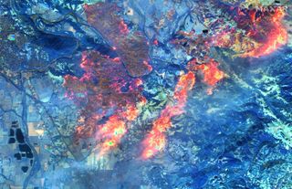
Gusting winds in northern California are helping the spread of the Kincade fire, as shown in a new animation from NASA. Meanwhile, Maxar Technologies captured infrared images the fire using its suite of Earth-observing satellites.

The winds, which are known as Diablo winds, have reached speeds as high as 96 miles (150 kilometers) an hour. This fuels the fires, making it more difficult for firefighters to keep them under control. The fire grew by nearly 48,000 acres (19,400 hectares) between Oct. 26 and Oct. 28 alone. More than 2,000 people have evacuated from the blaze, which has consumed more than 120 structures.

NASA's new animation visualizes data captured between Oct. 20 and Oct. 28, showing strong gusts in yellow and weak winds in purple. This data comes from the Goddard Earth Observing System Model 5 (GEOS-5), a weather model that NASA is experimenting with to better understand weather around the world. This model takes in data from 30 sources, 
such as satellites, ships, aircraft and buoys

.
A shortwave infrared satellite image shows the fire lines near Healdsburg, California, on Oct. 27.

"The Diablo winds tend to originate in the Great Basin region of Nevada and Utah," NASA said in a statement. "The winds are fueled by high-pressure air moving toward lower-pressure areas and lower elevations near the coast. On the way, the air masses pass over California’s mountain ranges and down through valleys, which causes the air to compress, heat up, and dry out. These hot, dry, gusty winds can exacerbate fire conditions and carry embers to the next patch of land."

Maxar's images show the fires burning on Oct. 27, courtesy of a type of infrared imaging (commercially unique shortwave infrared) that preferentially shows warmer and cooler areas in a particular zone. In a statement, Maxar said this type of imagery is useful for wildfire imaging, as the images tend to cut out obscuring smoke. Also, the shortwave infrared imagery easily shows which vegetation is burnt.

Source;Livescience

Comments